Published On:
June 22, 2026
Updated On:
June 22, 2026
The Union Ministry of Panchayati Raj is revolutionising rural navigation with a proposed Intra-Village Road Coding and Grading System that assigns a unique digital identity, standardized classification, and QR code signboards to every village road, bridging the gap between urban and rural digital infrastructure.
India has witnessed remarkable infrastructural growth over the past two decades, particularly in the realm of rural connectivity. Mega-initiatives have successfully laid down a vast network of all-weather roads connecting remote habitations to major district and state highways. However, while these arterial routes have effectively bridged the gap between villages and towns, a significant navigational challenge remains hidden within the villages themselves. The moment one steps off the main highway and enters the internal lanes of a rural settlement, the digital map often goes entirely blank.
Historically, intra-village roads and pathways have remained almost entirely undocumented, lacking formal names, standardized classifications, or reliable digital footprints. This absence of a structured addressing framework creates severe daily hurdles. Ambulances struggle to locate specific households during medical emergencies, postal workers and courier services face immense difficulties in executing last-mile deliveries, and government agencies find it challenging to monitor welfare schemes or assess infrastructure needs. Recognizing this critical gap, the Ministry of Panchayati Raj has proposed an ambitious, nationwide Intra-Village Road Coding and Grading System. This pioneering initiative is designed to assign a unique digital identity, a standardized grade, and a proper physical signboard to every single road, lane, and bylane within Indian villages, transforming them into smart, digitally navigable spaces.
The vision behind this massive digital reform is straightforward yet transformative: every internal road in every village across the country must have a unique, recognizable name and an alphanumeric code that is visible on a physical signboard, traceable on a digital map, and permanently linked to a verifiable national database. By establishing a uniform national framework for naming and coding these internal roads, the government intends to bring rural infrastructure management up to the level of precision and documentation typically associated with advanced urban municipal areas.
This initiative acts as a comprehensive digital road registry, enabling accurate mapping and classification of rural roads that have so far existed primarily in the local memory of the residents. It is conceived as a cohesive, whole-of-government exercise that seamlessly integrates the efforts of the Ministry of Panchayati Raj, the Ministry of Rural Development, the Department of Posts, the National Rural Infrastructure Development Agency, and various state governments and geospatial agencies. By creating a unified digital twin of the rural road network, this system will empower planners and administrators with real-time visibility, thereby preventing the duplication of public works across different departments and ensuring optimal allocation of development funds.
To bring order to the complex, organic layout of traditional Indian villages, the proposed system introduces a highly logical, three-tier classification for all internal roads. This grading mechanism ensures that every pathway, regardless of its size, is systematically categorized based on its function and connectivity.
First in the hierarchy are the Main Roads. These are the major thoroughfares that pass through the village, connecting one end to the other, or serving as the primary entry and exit routes linking the village to the external highway network. In the new standardized system, these will be numbered sequentially, such as Main Road 1, Main Road 2, and so forth. In cases where parallel main roads exist, alphabetical suffixes will be added for clarity, resulting in designations like Main Road 1A or Main Road 1B.
The second tier comprises Cross Roads. These are the secondary streets that directly intersect or cut across the Main Roads, facilitating movement between different neighborhoods or blocks within the village. Similar to the primary routes, these will be named and numbered sequentially as Cross Road 1, Cross Road 2, and so on, establishing a clear grid-like understanding of the village layout.
The third tier encompasses Other Roads and Connected Roads. These represent the smaller, narrower lanes, alleys, and paths that branch off from the Main Roads or Cross Roads, often leading deep into residential clusters. These will be assigned sequential codes, and to maintain absolute consistency, the numbering will follow a strict clockwise or anti-clockwise directional pattern across the village.
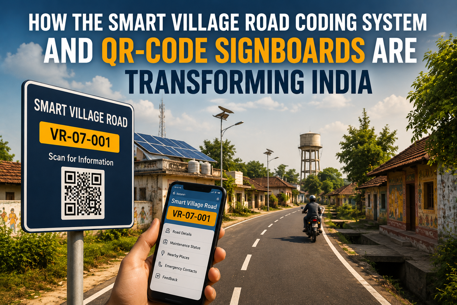
A standardized naming convention is only half the solution; the real innovation lies in the assignment of a unique alphanumeric code to every single road segment. This code acts as the digital DNA of the road, identifying its exact geographical and administrative location from the state level all the way down to the specific village lane.
The structure of this unique code is meticulously designed to provide immediate context. For instance, an internal village road might receive a code structured as IVR-MH-TN-BHW-001-1. Breaking this down reveals a wealth of information: the prefix indicates the specific road type, such as IVR for Intra-Village Road, VR for Village Road, or ODR for Other District Road. This is immediately followed by the abbreviation for the state, the abbreviation for the district, the code for the specific block or village, and finally, a unique sequential number assigned to that exact road.
This alphanumeric framework is intentionally engineered to be fully compatible with the existing codification standards used by the Pradhan Mantri Gram Sadak Yojana and the databases maintained within the Local Government Directory. To ensure absolute data integrity and prevent any possibility of duplicate codes being generated, every newly assigned alphanumeric identifier will undergo a strict validation process through the Online Management, Monitoring and Accounting System.
The physical naming and coding of roads are heavily supported by cutting-edge geospatial technology. Every internal village road will be tagged with a DIGIPIN code, an advanced geospatial identifier developed by the Department of Posts. Unlike a traditional postal PIN code that covers a broad geographic area, DIGIPIN provides precise latitude and longitude coordinates for a highly specific location. By assigning a DIGIPIN to these rural lanes, the system makes the roads completely machine-readable and universally compatible with modern GPS navigation systems and digital mapping platforms.
Serving as the central nervous system for this massive repository of data is Gram Manchitra, a sophisticated geospatial planning and monitoring application developed by the Ministry of Panchayati Raj. Gram Manchitra will act as the unified digital dashboard where all the unique alphanumeric road codes, the DIGIPIN spatial data, the Local Government Directory codes, and the infrastructure data converge. Through this single, integrated platform, government officials, urban planners, and ordinary citizens will be able to view, search, analyze, and monitor the entire rural road network with an unprecedented level of high-resolution imagery and accuracy that far exceeds standard commercial mapping applications.
The most visible and interactive aspect of this entire initiative will be the installation of physical signboards at the corners of these newly classified roads. Elevating the concept of a smart village road coding system, these signboards will prominently feature unique QR codes. This transforms a simple metal placard into a dynamic digital gateway.
Any citizen, traveler, or government official equipped with a smartphone can simply scan the QR code signboard to instantly access a wealth of localized data. The scan will automatically connect to the Gram Manchitra platform, revealing the road's exact name, its unique code, precise navigation data, and its comprehensive maintenance history. This direct access to digital records is a massive leap forward in rural e-governance, fostering a culture of extreme transparency.
Furthermore, these signboards will be strictly bilingual, featuring the road details in the regional local language alongside English. This inclusive approach ensures maximum accessibility and readability for local residents, visiting delivery personnel, healthcare workers, and emergency responders who may not be familiar with the native script.
The implementation of this digital addressing framework will have a profound, life-saving impact on rural healthcare and emergency response mechanisms. Currently, when a medical emergency strikes in a densely populated, undocumented village, ambulance drivers often lose precious, critical minutes navigating a maze of unnamed alleys, relying entirely on verbal directions from bystanders. Similarly, police units and disaster response teams face severe operational delays when trying to locate specific distress calls in deep rural pockets.
By establishing a precise, machine-readable addressing system, emergency vehicles equipped with GPS navigation will be able to route themselves directly to the patient's doorstep without hesitation. The integration of precise geospatial coordinates ensures that emergency responders can optimize their travel paths, bypass blocked alleys, and significantly reduce response times, fundamentally upgrading the safety and well-being of the rural populace.
Beyond emergencies, the unique road coding system will act as a powerful catalyst for the rural economy. In recent years, digital literacy and smartphone penetration have surged in rural India, leading to a massive spike in e-commerce demand. However, major logistics companies, courier services, and the traditional postal network frequently struggle with the complexities of last-mile delivery in areas that lack formal street addresses. Delivery agents often have to make multiple phone calls to customers just to find their homes, leading to inefficiencies, delayed shipments, and high operational costs.
With every lane mapped, named, and coded, rural addresses will become as precise and easily locatable as a numbered apartment in a metropolitan high-rise. This newfound navigational clarity will encourage logistics platforms and essential supply chains to expand their footprint deeper into the rural hinterland. It will also empower local rural entrepreneurs, artisans, and farmers, allowing them to ship their localized products to national markets with the confidence that logistics partners can seamlessly locate their workshops and farms.
A cornerstone of this initiative is the decentralization of authority, placing the power of infrastructure management directly into the hands of the local community. The Gram Panchayats, serving as the village councils, will be designated as the primary authority responsible for the identification, naming, and grading of the roads within their respective jurisdictions. This ensures that the newly assigned names reflect local culture, history, and community preferences, rather than being arbitrarily assigned by distant bureaucrats.
Moreover, the Gram Panchayats will incorporate the ongoing maintenance, annual reviews, and physical audits of these roads directly into their Gram Panchayat Development Plans. This local ownership fosters a deep sense of responsibility, ensuring that the signboards are maintained, the digital records are kept up to date with any new constructions, and the physical condition of the roads is regularly monitored by the very people who use them every day.
The integration of QR code signboards and digital mapping will virtually eliminate the systemic opacity that has long plagued rural infrastructure projects. Historically, isolated rural roads were susceptible to poor maintenance, substandard construction materials, and a lack of accountability regarding funds allocated for repairs.
By linking the physical QR codes directly to the maintenance history and the contractor details via the digital database, the system places immense power in the hands of the public. If a citizen notices that a recently paved road is already developing potholes, they can scan the signboard, view the exact date of construction, identify the responsible contractor, and verify the maintenance obligations. This public visibility acts as a powerful deterrent against negligence, ensuring that public funds are utilized effectively and that contractors are held strictly accountable for the quality of their work.
The Ministry of Panchayati Raj is currently preparing to release the comprehensive consultation document for the Intra-Village Road Coding and Grading System into the public domain. By actively inviting suggestions, feedback, and constructive criticism from citizens, local communities, elected representatives, academic experts, and geospatial organizations, the government is ensuring that the final framework is robust, inclusive, and technologically sound. Several state governments have already expressed keen interest in spearheading the pilot implementations of this digital registry.
As India continues its relentless push toward comprehensive digital governance, this road coding initiative represents one of the most critical missing pieces of the puzzle. It is not merely about putting up signboards or plotting lines on a digital map; it is about granting millions of rural citizens the dignity of a recognizable, functional address. By illuminating the undocumented pathways of rural India, the smart village road coding system and its accompanying digital infrastructure will permanently erase the navigational divide between cities and villages, paving the way for a truly connected, accessible, and empowered rural India.
