Published On:
April 8, 2026
Updated On:
April 8, 2026
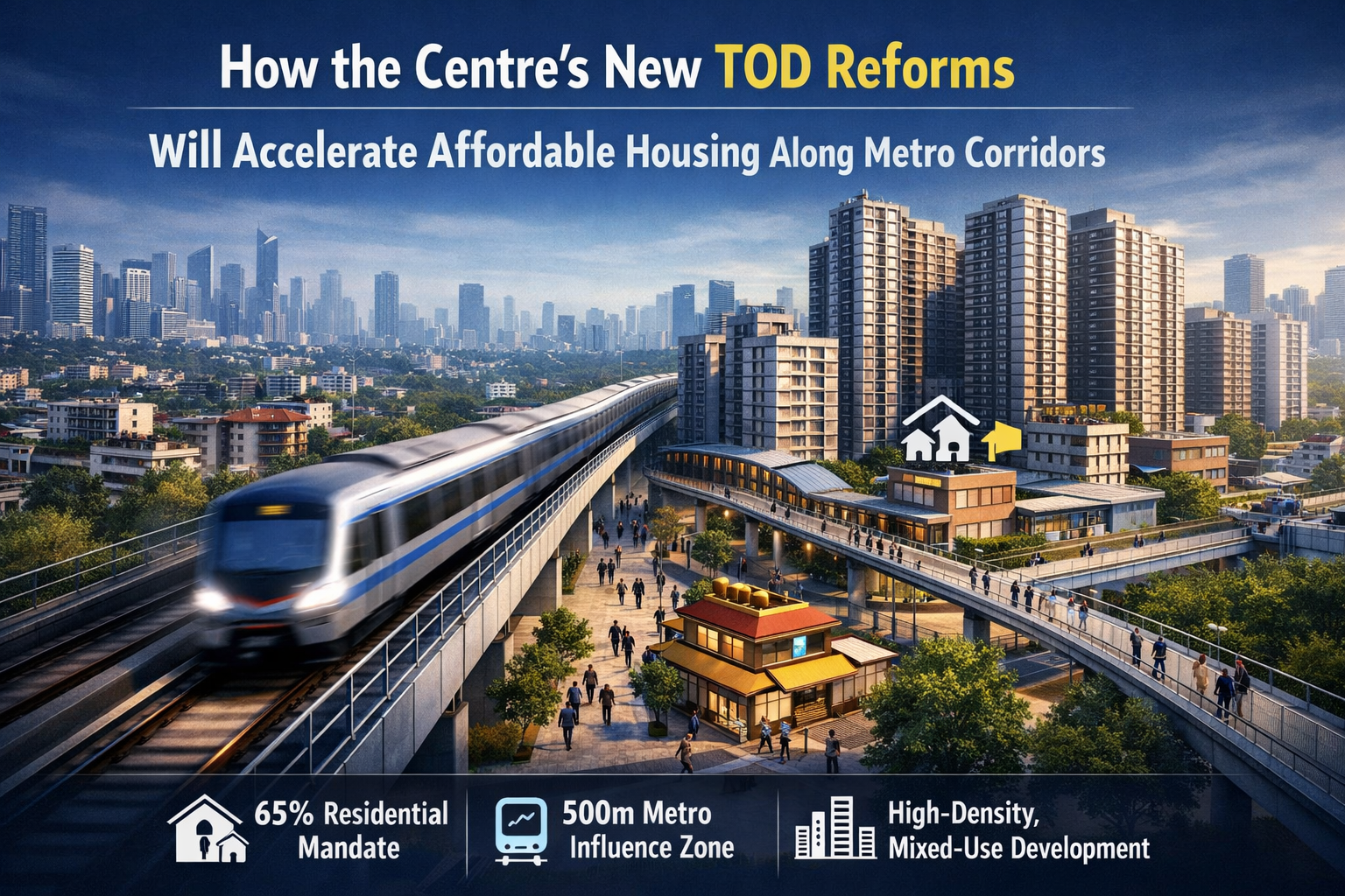
The Central Government has introduced transformative Transit-Oriented Development (TOD) reforms, slashing minimum plot sizes and mandating 65% affordable housing within a 500-metre radius of metro and rapid rail corridors. This sweeping move aims to boost high-density, mixed-use urban growth, ensuring seamless last-mile connectivity and faster real estate project approvals.
Urbanisation across the country is occurring at a breakneck pace, and with it comes the dual challenge of managing city sprawl and providing accessible housing. Addressing these intertwined issues requires visionary urban planning, which is exactly what the recent overhaul of the Transit-Oriented Development policy sets out to achieve. The Central Government has introduced sweeping reforms that will forever alter the skyline and livability of major urban centres, particularly along rapidly expanding mass transit networks. By strategically integrating land use with transport infrastructure, the updated norms promise to create vibrant, self-sustaining communities right alongside metro and rapid rail corridors.
These comprehensive changes are not merely administrative updates; they represent a fundamental pivot in how real estate near metro corridors will be developed, marketed, and inhabited. From heavily relaxed zoning laws to ambitious mandates for low-cost homes, this updated framework serves as a powerful catalyst for the real estate sector and a beacon of hope for middle-income homebuyers.
At its heart, Transit-Oriented Development is a globally recognised urban planning strategy designed to maximise the amount of residential, business, and leisure space within walking distance of public transport. The core philosophy is simple: build higher and denser near mass transit hubs so that people rely less on private vehicles, thereby reducing carbon emissions, traffic congestion, and lengthy commutes.
The latest TOD policy reforms approved by the Centre represent a massive leap forward in actualising this philosophy across Indian cities. Urban planning authorities have officially designated a 500-metre radius on both sides of any metro line or Regional Rapid Transit System corridor as exclusive TOD zones. In high-density metropolitan areas like Delhi, this encompasses a staggering 207 square kilometres of prime urban land perfectly primed for high-density, mixed-use planned development.
One of the most significant barriers to executing large-scale, transit-linked projects in the past was the rigid requirement for expansive land parcels. Historically, a developer needed a minimum of one hectare of land to even qualify for the benefits of the government's transit schemes. In heavily congested cities where land is scarce, fiercely contested, and highly fragmented, assembling a contiguous one-hectare plot is an operational and financial nightmare.
To resolve this persistent bottleneck, the updated policy has drastically reduced the minimum plot size requirement to just 2,000 square metres. This single, calculated change unlocks immense potential for mid-sized developers and independent landholders who previously found themselves locked out of high-density development opportunities. By lowering the entry barrier, the government is democratising real estate development along crucial transit routes. This will inevitably lead to a much faster pace of construction, a more diverse range of developers entering the market, and ultimately, a more dynamic urban landscape that efficiently utilises smaller, previously ignored land parcels near transport hubs.
While easing development restrictions is a major win for the commercial real estate sector, the policy goes a step further by weaving in a powerful social mandate. A critical component of the revised norms is the compulsory allocation of 65 percent of the total permissible built-up area specifically for residential use, featuring housing units with a built-up footprint of up to 100 square metres.
This targeted approach guarantees the creation of affordable housing precisely where it is needed most—along established public transit routes. For years, low and middle-income families have been pushed to the distant, disconnected fringes of cities due to sky-high property prices in central and well-connected areas. This uncontrolled urban sprawl forces them into long, exhausting, and expensive daily commutes. By mandating that the lion’s share of new transit-adjacent developments be dedicated to smaller, affordable units, the framework ensures that essential workers, young professionals, and middle-class families can afford to live near world-class transportation. It bridges the critical gap between housing affordability and mobility, creating inclusive neighbourhoods that cater to diverse socio-economic demographics.
To make affordable housing financially viable for developers, urban planners must offer compelling incentives. This comes in the form of a heavily relaxed Floor Area Ratio. FAR, an essential real estate metric that measures the ratio of a building's total constructed area against the size of its plot, ultimately determines how dense and tall a structure can legally be.
Under the newly issued guidelines, properties situated on plot sizes of 2,000 square metres and above, positioned adjacent to an 18-metre-wide road within a designated transit zone, can avail a maximum FAR of up to 500. To put this into perspective, if a developer owns a 2,000-square-metre plot in this specific zone, they are legally permitted to construct a building with a total floor space of up to 10,000 square metres—exactly five times the size of the land itself.
This incredible vertical growth allowance is an absolute game-changer. It offsets the astronomically high cost of land acquisition by allowing developers to build significantly more units on the exact same footprint. This high-density approach is the fundamental economic engine that makes affordable housing profitable. It empowers developers to absorb land costs and lower the selling price of individual residential units, passing the financial benefits straight down to the end consumer.
Modern urban planning is rapidly moving away from the outdated concept of strictly segregated residential and commercial zones. The old model, which forces people to commute vast distances from quiet suburban bedrooms to bustling downtown financial districts, is inherently inefficient and damaging to city infrastructure. The revamped TOD norms actively dismantle these outdated land-use restrictions.
Within these high-value transit corridors, developers are now actively encouraged to embrace mixed-use projects. While 65 percent of the space is fiercely protected for affordable homes, the policy stipulates that out of the remaining 35 percent of the floor area ratio, at least 10 percent must be dedicated to commercial setups and local amenities. This translates to ground floors and lower levels of massive residential complexes legally housing grocery stores, pharmacies, co-working spaces, cafes, clinics, and essential retail outlets.
By integrating commercial real estate directly alongside housing, these zones will transform into self-contained micro-economies. Residents will have the luxury of stepping out of their apartment lobbies and finding all their daily necessities, and potentially even their workplaces, within the same complex or just a short stroll away. This localised convenience is the ultimate hallmark of a resilient, sustainable city.
The real estate industry is notoriously plagued by severe bureaucratic delays. Securing the necessary permits to begin construction can often take years, tying up capital and heavily inflating the final cost of housing. Recognising that time equates to money in the construction sector, authorities have integrated a powerful ease-of-doing-business component into the reforms.
A dedicated committee has been constituted with the explicit mandate to process and clear real estate proposals through a highly streamlined, single-window system. Most importantly, this governing body is bound by a strict 60-day timeline to grant development sanctions from the moment a valid proposal is received. This rapid turnaround time provides developers with much-needed predictability. When construction timelines are guaranteed, financial modelling becomes far more accurate, investment risk is minimised, and critical housing projects can be delivered to waiting buyers much faster.
Alongside the expedited approval process, the financial framework governing these developments has been simplified and made completely transparent. Planners have established a flat development charge of ₹10,000 per square metre. Instead of this money disappearing into general state coffers, it will be meticulously collected and deposited into a secure, ring-fenced escrow account.
This specialised fund is exclusively earmarked for the infrastructural development and civic upkeep of the transit zones themselves. The capital will be distributed directly among essential civic bodies—such as municipal corporations and local water boards—to ensure that the high-density areas receive the necessary, immediate upgrades in sewage management, water supply, and electricity grids. This self-sustaining financial loop ensures that the intense real estate development does not outpace the local civic infrastructure, preventing the new high-rises from becoming burdens on the city's existing, often fragile resources.
A mass transit system is only as effective as its ground-level accessibility. If commuters have to navigate broken sidewalks, dangerous intersections, or chaotic traffic just to reach the metro station, they will likely revert to using private cars. The new framework actively addresses this by weaving last-mile connectivity directly into the architectural blueprints of new buildings.
Developments falling under these guidelines will feature enhanced walkability infrastructure. The policy strongly encourages the construction of new underground subways and elevated pedestrian walkways that connect directly from the residential plots straight into the concourses of the metro and rapid rail stations. Residents will essentially be able to leave their homes and walk directly to the transit platform without ever having to step onto a busy, polluted street. This level of seamless, weather-protected integration not only boosts public transport ridership but significantly elevates the quality of life, safety, and convenience for the residents.
Beyond the immediate economic and housing benefits, the transition toward transit-oriented urban planning carries profound environmental implications. Cities routinely grapple with severe air quality issues, a massive portion of which can be directly attributed to vehicular emissions from millions of private cars and two-wheelers stuck in gridlocked traffic. By designing neighbourhoods where living, working, and shopping are all contained within a short walk from a mass transit station, urban authorities are fundamentally altering daily commuter behaviour.
When high-quality, affordable housing is coupled with direct pedestrian walkways to metro stations, the reliance on fossil-fuel-powered personal vehicles naturally plummets. Residents can effortlessly adopt a zero-emission daily routine, utilising the electric rail networks for long distances and safe, elevated walkways for local movement. Over time, this massive reduction in daily car trips will drastically lower the carbon footprint of these high-density nodes, fostering a greener, more breathable urban environment.
While metro networks have historically served intra-city travel, the inclusion of the Regional Rapid Transit System within this policy framework expands the horizon of this initiative dramatically. Rapid rail corridors are designed to connect distant satellite towns and suburban nodes with central metropolitan areas at exceptionally high speeds, effectively shrinking the geographical footprint of massive urban agglomerations.
Applying the relaxed development norms to these rapid rail corridors means that affordable, high-density housing will not just be confined to expensive city centres. Developers can now leverage the high floor area ratio and reduced plot size requirements in emerging, previously remote suburban transit nodes. This decentralisation of development ensures that population density is distributed more evenly across the broader region rather than suffocating the core city. A young professional could easily afford a well-sized home in a rapidly developing suburban rail node and commute to the central business district in record time, enjoying the best of both suburban affordability and urban opportunity.
From an investment and market perspective, these sweeping reforms act as a massive stimulus for the real estate sector. The strategic corridors stretching along metro networks will quickly become the most sought-after real estate in the country. For developers, the combination of vertical growth allowances, rapid approvals, and the removal of mixed-use restrictions presents a highly lucrative, highly scalable business model.
For prospective homeowners and retail investors, buying property within these designated zones represents a secure and rapidly appreciating asset. Properties located within walking distance of reliable public transport historically appreciate at a noticeably faster rate than those in poorly connected areas. Furthermore, the mandatory inclusion of commercial spaces guarantees a steady, reliable rental yield for those investing in the retail components of these mega-projects.
The recent overhaul of the transit development norms is not just a minor policy tweak; it is a foundational blueprint for the future of urban living. By simultaneously addressing the critical need for affordable housing, maximising the utility of expensive urban land, and championing eco-friendly public transport, authorities have created a holistic solution to some of the most pressing urban challenges of our time.
As the physical landscape of these transit zones begins to transform, bringing high-density residential towers and bustling commercial hubs to life, the ripple effects will be felt across the entire economy. Reduced commute times will lead to higher workforce productivity, lower vehicular emissions will clear the air, and the widespread availability of affordable homes will provide deep economic stability for millions of families. This visionary alignment of real estate development with mass transit infrastructure ensures that our cities will remain dynamic, highly inclusive, and remarkably sustainable engines of economic growth for generations to come.
