Published On:
April 14, 2026
Updated On:
April 14, 2026
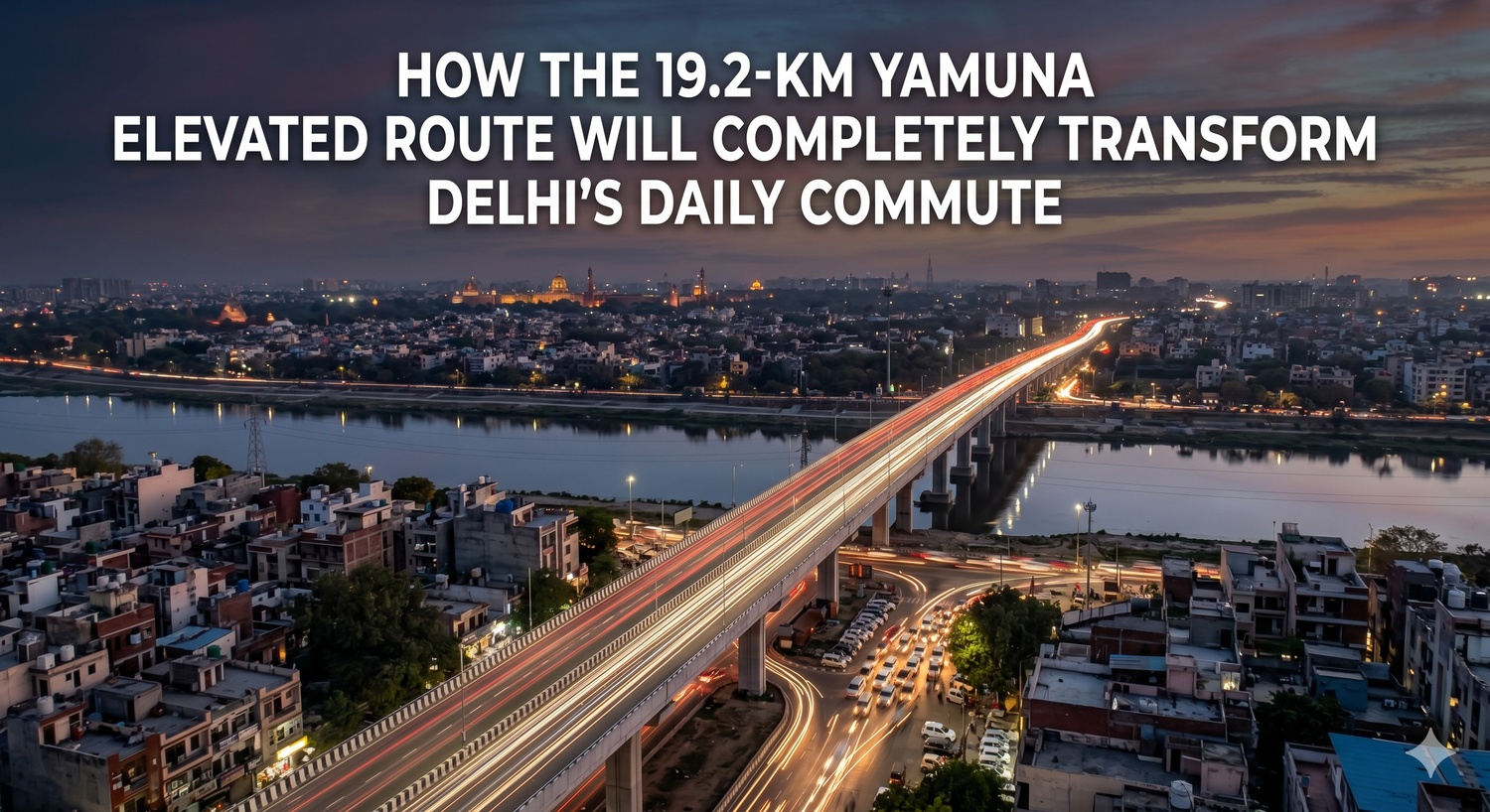
The proposed 19.2 km Yamuna elevated route from Wazirabad to the DND Flyway is a massive infrastructure upgrade designed to completely bypass Delhi's worst traffic bottlenecks. By providing a signal-free corridor, this project will slash travel times, decongest the Ring Road, and trigger a significant real estate boom across North Delhi and Noida.
Anyone who navigates the arterial roads of the national capital knows the daily, exhausting reality of the Ring Road. Commuting from the northern stretches of the city towards the commercial hubs in the south or across the border into Noida is rarely a smooth experience. The journey is defined by a series of notorious choke points—the crawling traffic at Majnu Ka Tila, the endless bumper-to-bumper wait near ITO, and the absolute chaos of multiple highways converging at Sarai Kale Khan. For years, commuters have accepted this loss of time and productivity as the inevitable cost of living in one of the world's most densely populated metropolises. However, a monumental shift in urban mobility is currently on the drawing board.
The Delhi government and the Public Works Department have unveiled a highly ambitious proposal to construct a 19.2 km Yamuna elevated route. This is not just another localized flyover intended to fix a single intersection. It is a sweeping, comprehensive transit corridor designed to run parallel to the Yamuna River, effectively creating an uninterrupted, high-speed expressway cutting directly through the eastern flank of the capital. By physically lifting traffic above the congested surface streets and linking Wazirabad in the north straight to the Delhi-Noida Direct Flyway in the south, this megaproject promises to fundamentally alter the geography of travel, real estate, and economic movement across the National Capital Region.
To truly understand the scale and impact of this infrastructure project, it is essential to look at how the route has been engineered. The initial concepts for decongesting the riverfront were much smaller in scale, originally envisioning a shorter elevated stretch connecting the Signature Bridge down to the Salimgarh Fort bypass. However, recognizing that a partial fix would simply push the traffic bottleneck further south, urban planners expanded the vision into a comprehensive 19.2-km master plan. The current proposed route is strategically divided into three highly functional phases.
The first phase initiates the high-speed corridor by connecting Surghat to the Inter State Bus Terminal at Kashmere Gate. This northernmost stretch is crucial because it immediately addresses the heavy commercial and passenger traffic originating from North Delhi and neighboring state borders, capturing vehicles before they can clog the local surface roads.
The second phase is arguably the most complex and vital segment of the entire project, stretching from the Kashmere Gate ISBT all the way to Sarai Kale Khan. This specific alignment shadows the riverbank right behind some of Central Delhi's busiest and most frustrating transit zones, including the Rajghat and ITO stretches.
The final phase completes the circuit by taking the elevated road from Sarai Kale Khan and dropping it directly onto the DND Flyway. This creates a seamless, high-speed ramp into the commercial heart of Gautam Buddha Nagar. Together, these three phases form a continuous, unbroken spine that bypasses the traditional city grid entirely.
The most immediate and tangible benefit of the 19.2 km Yamuna elevated route is the complete eradication of signal-based waiting times for cross-city commuters. The surface-level Ring Road currently forces drivers to navigate through several high-density local transit hubs.
Consider the situation at Majnu Ka Tila. It is a vibrant cultural and commercial hotspot, but its location on the primary arterial road means that heavy highway traffic is constantly forced to slow down to accommodate local pedestrians, cycle rickshaws, and parked tourist buses. Further down, the Metcalfe House stretch suffers from a similar volume overload.
Then comes the ultimate bottleneck: Sarai Kale Khan. This junction is an absolute nightmare for urban planners because it serves as the convergence point for the Ring Road, National Highway 24, a massive interstate bus terminal, and the new regional rapid transit systems. Attempting to funnel local city traffic, interstate buses, and logistics freight through this single ground-level node creates daily gridlock.
By constructing an elevated route that sails high above these specific friction points, the new corridor separates inter-city commuters from local neighborhood traffic. A professional driving from Timarpur to a corporate office in Noida Sector 16 will no longer have to tap their brakes at ITO or wait for multiple signal changes at Sarai Kale Khan. The journey becomes a continuous, high-speed cruise, shaving massive amounts of time off the daily commute and dramatically reducing driver fatigue.
Brilliant urban infrastructure does not operate in isolation; it acts as a force multiplier for existing networks. The alignment of the Yamuna elevated route is heavily optimized to integrate with the massive bridges and bypasses that already cross the river.
At its northern anchor, the project leverages the connectivity of the iconic Signature Bridge at Wazirabad. The Signature Bridge already does the heavy lifting of pulling traffic from Trans-Yamuna areas like Bhajanpura and Yamuna Vihar into North Delhi. The new elevated road will intercept this incoming traffic and provide it with a direct, high-speed southern trajectory.
Similarly, on the southern end, the project integrates flawlessly with the DND Flyway and operates in synergy with the broader Kalindi Kunj transit network. While plans are simultaneously underway to build new bridges and bypasses near Kalindi Kunj to ease the Noida-Faridabad movement, the Yamuna elevated road acts as the central vertical artery feeding these horizontal river crossings. By linking the Signature Bridge, the older iron bridges, the Nizamuddin bridge, and the Barapullah elevated corridors to this single high-speed spine, the city is essentially creating an intelligent, multi-tiered grid that distributes vehicular weight evenly.
Whenever you drastically reduce travel time between a major residential hub and a primary commercial district, the real estate market experiences a profound realignment. The implementation of the 19.2 km Yamuna elevated route will act as a massive catalyst for property valuations and investment strategies across several micro-markets in the National Capital Region.
For decades, the property markets in North Delhi—encompassing areas like Civil Lines, Model Town, and the neighborhoods surrounding Delhi University—have operated somewhat independently from the booming IT and corporate sectors of Noida. The sheer physical exhaustion of a two-hour commute deterred professionals from living in the north while working in the south-east. The elevated corridor completely shatters this geographical barrier. When the commute from Wazirabad to the DND drops to a predictable, rapid drive, the residential appeal of North Delhi will surge among top-tier corporate executives. We can expect a significant appreciation in premium residential property values in these older, established neighborhoods as they become highly viable bases for Noida-bound professionals.
Conversely, the real estate landscape in Noida and Greater Noida will also reap massive benefits. Developers in Gautam Buddha Nagar have often struggled to market their luxury apartments to traditional Delhi business families who are deeply rooted in the capital's northern and central districts. The promise of a signal-free, scenic drive above the Yamuna riverbed makes relocation or investing in a second home in Noida much more palatable.
Furthermore, the areas in East Delhi adjacent to the riverbank, which are often heavily congested, will see a revitalization. As heavy through-traffic is diverted onto the elevated corridor, internal Trans-Yamuna roads will experience a drop in congestion, making local commercial markets and residential colonies far more accessible and desirable.
Beyond the highly visible impacts on real estate and commuting convenience, the broader macroeconomic and environmental benefits of this project are substantial. A heavily congested Ring Road acts as an invisible tax on the city's economy. Commercial light vehicles, delivery fleets, and supply chain logistics burn massive amounts of fuel and lose thousands of hours simply idling in traffic near ITO and Kashmere Gate. By providing a free-flowing bypass, the elevated road optimizes commercial movement, lowering operational logistics costs for businesses across the capital.
Environmentally, the project addresses one of Delhi's most pressing concerns: vehicular emissions. Stop-and-go traffic is the primary culprit behind the severe localized air pollution hotspots found at major intersections. An engine idling in a massive traffic jam at Sarai Kale Khan produces a significantly higher concentration of toxic emissions than a vehicle cruising at a steady speed on an expressway. By enabling a continuous flow of traffic, the elevated corridor ensures vastly improved fuel efficiency and a direct reduction in the carbon footprint of millions of daily commutes. It is a structural intervention that supports the city's desperate need for better air quality.
Executing a 19.2 km elevated highway directly along the banks of a major river is an engineering feat that comes with immense complexities. The Public Works Department will have to navigate a highly sensitive ecological zone. The Yamuna floodplains are a critical environmental asset for the capital, acting as natural water recharge zones and ecological buffers. The construction methodology will require meticulous planning to ensure that the massive concrete pillars do not obstruct the natural flow of the river during the monsoon season or permanently damage the fragile floodplain ecosystem.
Additionally, managing the construction logistics within an already hyper-congested city will be a monumental task. Building massive elevated structures over active traffic zones like the ISBT and ITO requires precision phasing and temporary traffic diversions that will inevitably cause short-term disruptions. However, the administrative machinery of the capital has successfully delivered massive, complex projects like the expanding Metro network and the Barapullah corridors under similar constraints. The short-term inconvenience of construction barricades is a necessary stepping stone toward permanent infrastructural relief.
The proposal for the 19.2 km Yamuna elevated route is a clear indication that piecemeal road widenings and localized traffic management are no longer sufficient for a rapidly expanding metropolis. To keep the city functional, urban planners are boldly looking upward.
This access-controlled corridor from Wazirabad to the DND Flyway is set to become one of the most critical infrastructural lifelines in Northern India. It embodies a modern, aggressive approach to urban design—one that prioritizes uninterrupted flow, strategic integration with existing transit networks, and massive time savings for the common citizen. As this ambitious blueprint slowly transitions from planning committee rooms to physical construction, the anticipation within the real estate market and the daily commuting public is palpable. Once completed, this elevated expressway will not merely decongest the surface streets; it will permanently elevate the living standards, economic efficiency, and real estate dynamics of the entire Delhi NCR.
